News
Tetra Tech Purchases Teledyne’s CZMIL SuperNova to successfully complete NOAA's Great Lakes Coastal Mapping project
Vaughan, Ontario, CANADA – March 12, 2024 – Teledyne Geospatial is pleased to announce that Tetra Tech, Inc., a leading provider of high-end consulting and engineering services, has purchased a Teledyne Optech CZMIL SuperNova Topobathymetric lidar system and have successfully completed a project for the National Oceanic and Atmospheric Administration (NOAA).
NOAA has an ongoing effort to update all their bathymetric maps in the Great Lakes region, which includes refined maps of the marine ecology. This necessitates obtaining accurate digital elevation models and reflectance products. The updated information will aid in enhancing the understanding of the Great Lakes hydrography and ecosystem.
Tetra Tech operated Teledyne’s Optech CZMIL SuperNova system for its best-in-class depth penetration and high-density mapping capability. The CZMIL SuperNova enabled mapping of the lakebed to a maximum depth of 31 meters. The intensity raster product, crafted with input from NOAA, served as a valuable tool for benthic habitat modeling and the full waveform data will contribute to further research questions. At the end of the project, Tetra Tech delivered classified point clouds and gridded products.
“The CZMIL SuperNova enabled Tetra Tech to exceed the project's density requirements, achieving approximately five points per square meter for bathymetric bottom density and an impressive 89 percent bathymetric bottom coverage across the Area of Interest,” said Renee Walmsley, Vice President for Tetra Tech Geomatics and Remote Sensing. “Tetra Tech is dedicated to continuous improvement and innovation in bathymetric lidar technology and is enthusiastic about exploring diverse environments worldwide, leveraging the CZMIL SuperNova system's capabilities,”
“We are particularly pleased to see the CZMIL SuperNova excel on this NOAA project and are driven by advancing 3D topo-bathymetric lidar solutions that help map and manage such aquatic environments. It is also our pleasure to support Tetra Tech on high impact projects like this one,” commented Malek Singer, Airborne Product Manager, Teledyne Geospatial.
Tetra Tech is the leader in water, environment and sustainable infrastructure, providing high-end consulting and engineering services for projects worldwide. With 28,000 employees working together, Tetra Tech provides clear solutions to complex problems by Leading with Science® to address the entire water cycle, protect and restore the environment, design sustainable and resilient infrastructure, and support the clean energy transition. For more information about Tetra Tech, please visit tetratech.com or follow us on LinkedIn, and Facebook.
Teledyne Geospatial unifies the hardware and software expertise of Teledyne CARIS and Teledyne Optech. The group provides customers with innovative integrated solutions. Offerings include turnkey systems, lidar and sonar integrated workflows and a range of systems and solutions that support holistic, precision data collection.
For media enquiries, please contact:
Jennifer Parham|
Jennifer.Parham@teledyne.com
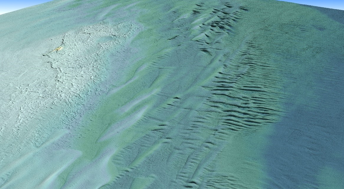
An oblique view of a Digital Elevation Model (DEM) derived from topobathymetric lidar collected by Tetra Tech's CZMIL SuperNova. This view is looking northwest across Lake Superior towards Tahquamenon Island in Whitefish Bay.
Join our Mailing List
Subscribe to email announcementsOur Latest Tweets
Tweets by Teledyne CARIS Follow us on TwitterConnect With Us
